
Data captured by drones and the analytics that go with it provide an accurate and comprehensive assessment of a site or a tower at any specific moment in time. The high-resolution imagery and precise identification and measurements of virtually everything on the asset, provided by Pointivo, delivers value at every stage of the lifecycle of a tower. From site selection and initial construction, through all modifications, up to and including the sale of the tower, near real-time accurate digital data on the tower and compound provides remote access to the actual site status and condition. A single version of the truth, available to all stakeholders.
TIA-222: Checking the Structural Condition of a Tower
Every five years for monopoles and self-supported towers, and every three years for guyed towers, tower owners will evaluate the condition of their structures according to the TIA-222 standard. The standard covers requirements for towers and antenna mounts to ensure they have the structural capacity to support all the antennas and other equipment, especially under severe weather conditions.
“The inspections have always been performed by climbers,” said Pat Lien, VP of Sales & Marketing at Pointivo. “But with the shortage of crews industry wide, drones are being considered by the TIA as a way to increase the industry capacity to perform these inspections.”
Up-to-date Digital Database
As companies regularly fly drones to augment a TIA inspection, it creates an up-to-date digital database. This gives a tower owner or engineering company the data they need at their fingertips and eliminates the need to visit the site to recapture data.
“Our customers have a huge competitive advantage because of this,” Lien said. “With advanced analytics and artificial intelligence, we can automatically identify the changes from the last drone capture and provide them to the tower owner, the carrier, or the service provider. From one point in time to the next, we can automatically identify everything that has changed.”
Pre-inspection for Maintenance Climbs
According to Lien, drones also enable crew efficiency, as pre-inspection flights before the crew arrives can minimize the time crews need to spend on site. It prepares them for minor maintenance that may need to be performed, allowing the crew to perform the maintenance in a single visit during the TIA, saving time and in turn, money. It also identifies what parts or supplies the crew needs to bring with them. “Eliminating repeat site visits is a huge driver toward drone adoption in the industry,” Lien said.
Drones + AI = Efficient Mount Structural Analysis
To perform a mount structural analysis, detailed information on the antenna mount assembly and the supported equipment is essential. Scheduling tower crews for mount mapping, especially when the industry activity is high, can take as long as 6-10 weeks. Drone captured data and Pointivo’s advanced analytics platform, however, reduces the timeline for a mount mapping from several weeks to five or six days.
“It’s a gamechanger in the deployment process and ultimately in the lifecycle of a tower,” explains Lien. “Pointivo’s AI is key to automating the extraction of data from the digital twin and reducing the analytics process to under 48 hours.”
The drone-captured data and AI-driven analytics, in addition to reducing timelines, also delivers engineering-grade accuracy, which is critical to the structural engineer performing the analysis. Standard report formats, Autocad and RISA-3D DXF files, and access to all imagery and the extremely accurate digital twin, are all part of a Pointivo mount mapping deliverable. Engineers that previously spent as much as 4-6 hours reviewing and transcribing mount mapping data are now spending less than 30 minutes reviewing a Pointivo report.
Pre- and Post-construction Costs
Repeat site visits to verify pre-construction conditions can be very costly, according to Lien. “Sending a crew to perform work on a site only to find out they can’t do their job because of unexpected conditions adds up,” says Lien. “Drone captured data provides detailed imagery and dimensional data that allows tower services companies to accurately scope the work and send out crews completely prepared to do their job without repeat visits.”
Post-construction, both the carrier and tower owner want to know that the install or mod has been done correctly and in compliance with the terms of the lease. “Lease compliance and closeout inspections are the most common reason for tower owners to use drone captured data, today,” Lien said. “Our customers receive detailed, accurate reports along with the digital twin and imagery quickly, allowing them to determine whether a job is complete before a contractor crew moves on to the next job.”
Structural and Civil Engineering: Aided by Accuracy
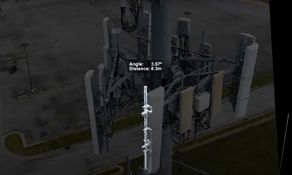
To perform any structural analysis of a mount, accurate measurements of all of the elements on the mount need to be determined. Antennas, remote radio units (RRUs) and all of the mount members are captured with drone imagery to create a highly accurate digital twin. Scaling and orienting the digital twin is critical to extracting accurate measurements. Pointivo says it has partnered with many of the largest and most stringent tower owners and engineering firms, whose feedback drove the R&D that delivered the extremely accurate 3D models.
“Pointivo’s patented and automated scaling methodology delivers accuracy to 1.5 millimeters over a RAD center and then those measurements are validated through the imagery itself, verifying the precise dimensions of each member,” Lien said. “Unfortunately, some companies provide a digital twin from drone data whose actual accuracy may be off by as much as 6+ inches, so it’s important to partner with a trusted provider that can guarantee engineering grade accuracy.” Pointivo now has 20 patents supporting their leading-edge analytics platform, automation, and data collection processes.
M&A Evaluation: the End for One Company, the Beginning for Another
Selling a portfolio is the end of the lifecycle for a cell tower developer. Of course, at the same time, it is the beginning of the life cycle for the buyer. Anytime a portfolio is evaluated for acquisition, due diligence is completed to fully verify the condition and capacity of the assets. Most tower portfolios cross multiple state lines and some may be in another country on another continent, complicating the process.
Pointivo’s analytics provide not only the high-resolution imagery of the site but also the detailed measurement data on the tower and RAD centers, allowing for clear assessment of the assets in the portfolio. How many tenants are on the tower? How much space are they paying for? How many more tenants can be added? What is the physical condition of the structure?
“We are seeing tower owners and developers moving to digitize their asset portfolios as the buyers have begun seeking a much greater level of due diligence on the tower portfolios that they acquire,” Lien said. “Because of the time it would take to evaluate an entire portfolio, buyers have traditionally used a small sample to perform due diligence. Today, using drones and automated analytics, due diligence can be performed on full portfolios in a small fraction of the time.”
Pointivo also provides a patented virtual walk in 3D, synchronized with the corresponding 600-1,200 tower images of the entire asset. Sitting at a computer anywhere, one can see the entire tower and compound as if they were climbing it.
Drone Analytics: Past, Present and Future
Drone analytics have come a long way in the past few years. What started as basic tower data and image capturing, has now evolved into a comprehensive repository of near real-time site and tower data – a single version of the truth – referenceable and shareable among all stakeholders. Solutions that deliver accuracy and speed save time and money across the lifecycle of a tower. However, for this solution to have industry-wide impact, it also had to be scalable. Pointivo has demonstrated just that – for more than 50,000 towers.
But that’s not where it ends. “Advances in drone automation – a drone in a box – will continue to streamline data collection” says Lien. “In the near future, people will be relieved from performing repetitive data capture-related tasks through advances in automated drone flights. Instead of someone initiating and controlling drone data capture, the system of the future will be fully automatic with minimal oversight.”
Drone captured data with AI-driven analytics is quickly becoming the standard for site and tower assessment for the wireless industry, according to Pointivo. This will allow tower crews to focus on tasks that are far more valuable, such as the modifications and installs that only crews can perform.
For more information, visit Pointivo’s homepage, follow their LinkedIn page, or read their recent blogs. You can ask a particular question via email to Team@pointivo.com.
original article published on Inside Towers on October 18, 2022 by J. Sharpe Smith
High-Precision Telecom Management
How to get decision-quality data from your drone program?